Trip Reports
 Disneyland MTB Ride
On the night before Johann and I did
this ride we had camped in the Chief's parking lot beside the highway.
Our plan was simple. We would save the $150 helicopter ride to the top
of Goat Ridge by strapping our bikes to our backs and walking up.
We didn't know if there was still a trail up to Goat Ridge but we knew
there once was one via Petgill Lake. Also we didn't know where the
somewhat famous Disneyland Trail came down. Only that it started on
Goat Ridge and ended in Britannia.
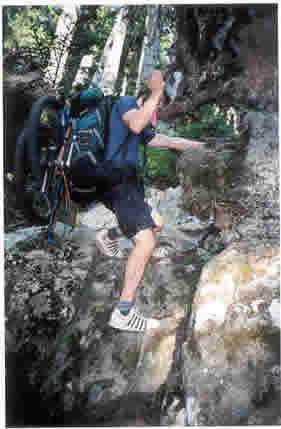
We walked to Petgill Lake without incident and stripped down for a dip.
Then sniffed around a bit for the trail that was supposed to continue
on. We found a flagged route off to the right (south side) of the lake
and followed it up. The trail was non-existent at times and is really
steep also. There is one section that has a fixed rope to ease
progress. After about five hours from the Murrin parking lot we started
topping out and into smaller trees and tarn country. There the trail
started to become more prominent. We knew that at six hours we would
have to turn back and, if we couldn't find Disneyland, we would just
have to walk back down the hellish route we took up. We started walking
faster so as to avoid this. At six hours with no sign of Disneyland I
stopped to contemplate our situation. Johann just then noticed an "H"
made out of stones that we took for a helicopter landing site! I was
elated. This is at 5100ft. We still didn't know where we were going but
things were looking up.
We rode back down our route, keeping an eye wide open for a trail on
our left. This section of the ridge is alpine rock, snow and some
sections of trail. Really technical riding some of which I didn't walk.
I told Johann to be extra cautious because I knew that he likes to ride
just beyond his limits. I figured that this was not the ride to have
someone get hurt on. Minutes later I watched as he bounced out of
control down a really steep section and almost held it together. He
took a good spill but only enough to make him sore for the following
week but not enough to slow him down for this ride.
Just as we got close to the end of the alpine/tarn portion of the ridge
we found what we were looking for. There was some sort of ATV sign a
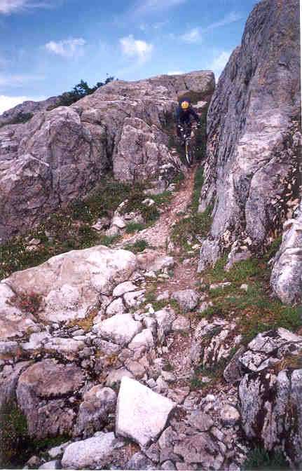
short way down to give us further encouragement. We rode some of the
best trail I have ever been on. Really steep sometimes flowing single
track with absolutely no built up sections. All natural. So steep that
when I couldn't hold on anymore I would fall off the back of my bike
and continue to slide at speed for a short while. We got lost for a
short time because we had to ascend for a section and that made us
nervous. The trail just never seemed to end. The valley bottom when it
could be seen was not getting closer. We spent four hours all told
descending. A fair return on our investment for sure.
We got spit out on a road that took us into Britannia and I hitched
back to the car.
Update 2003:
In late September 2003, Matt Smith joined Johann and myself and did the
same ride in the same manner. It took an extra hour to get to the top
but for the most part everything was just as fine as the first year. We
had parked in Britannia and biked up to the start. Johann reported that
he suffered a week of giardia in Europe after our last trip as we drank
some tarn water due to me being too stupid to bring water. I had just
brought an empty 750ml water bottle.
Update 2004 :
Self-Propelled Finally! On August 14th 2004, (seven days after my
wedding to Nola) Johann, Matt and myself met in Britannia to do the
trip once again. Johann had sworn to never suffer the approach again
but after 11 months he seemed to have forgotten this.
Matt arrived nine minutes late and apologized. Then he asked me what
time it was. I told him he was only nine minutes late and he was
astounded. He hadn't checked his watch since 3pm the day before. Matt
had agreed to "lead" this trip for the Self-Propelled Outdoor Club the
year before. Unfortunately he had moved to Roberts Creek since. The
club rules clearly prohibit the use of ferries and so Matt was obliged
to kayak from Port Melon after biking it there from home. He had camped
on the north side of Gambier Island the night before. Johann and I met
in the downtown east side at 5:15am and biked to meet Matt. As we
waited we watched a helicopter fly off with eight bikes hanging below.
We still don't know where it was headed but we took a picture of it and
had a laugh.
It took nine hours from the start of the trail this year as we were a
little bit tired and we had some bivy gear and booze on board. We drank
a small amount of scotch at the top and past out fairly early. Since
Nola had had a Stagette but I hadn't had a Stag we declared this my
Stag party. It lasted about 20 minutes and consisted of Johann shaking
uncontrollably while smoking and joint and drinking scotch. Matt and I
stayed up only five extra minutes and shamed our families by not
finishing the scotch. We woke up and fixed this by polishing off the
extra. Then we set off to ride the trail. All was well until we did the
traverse uphill and it got very bright very fast. There is now a
logging road cutting through right here. We found the trail up hill 50
or 100m up the road from here. A small amount of riding brought us to
the same road but lower down. The trail picked up directly below. Some
of the trail down lower (old logging road with deep water bars) was
really overgrown. Then the really great riding section followed. Smooth
flowing fast single track with a steep angle. After this you push up
hill and back into more cut trees to try to walk over and through. Then
it's just a matter of finding a way out by way of a logging road. So
the quality of the lower trail is being jeopardized by logging in the
area.